Constellation Boundaries Update: 21st Century
Reassessing Constellation Boundaries: Bridging Historical Context and Modern Utility
Cara Mico, Seattle, Washington, USA
1. Purpose
My central argument is that scientific sky mapping, built on coordinate systems and reference frames, should be divorced from the constellations, and that constellation boundaries should be left to the people of each time and culture. Constellation boundaries, standardized by the International Astronomical Union (IAU) in 1930 under Eugène Delporte, transformed the sky into 88 rigid regions bounded by lines of right ascension and declination, prioritizing scientific precision over historical fluidity [1, 2]. While this framework enabled global astronomical collaboration, its straight-line approach often clashes with the organic shapes of ancient asterisms and excludes non-Western traditions, such as the Chinese lunar mansions [3]. I ask: if these lines are arbitrary, what purpose do they serve in today’s diverse astronomical landscape?
The purpose of this report is to reassess the IAU’s 1930 constellation boundaries in the light of their history and their modern use. Building on Babylonian, Greek, and IAU frameworks, I address three questions: Who uses these boundaries today? Do they still serve their intended purposes? And should scientific mapping rest on coordinate systems and reference frames, leaving constellation boundaries to the people of each time and culture?
I pursued these questions along three lines of inquiry. First, I examined the cultural rationale for the constellations’ locations, including their historical role as seasonal markers for the onset of rain. Second, I reviewed the history of Delporte’s work: his epoch, coordinates, datasets, and selection criteria. Third, I examined the IAU reference systems, from the Besselian epoch used in 1930 (B1875.0) to J2000.0 and the International Celestial Reference System (ICRS). My detailed boundary analysis focuses on the Aquarius–Pisces region, examined with Carte du Ciel software and historical star charts [4].
Finally, the report sets out a proposal: a dual system that preserves cultural asterisms as a historical archive while establishing a universe-centric astronomical mapping reference system based on the ICRS and Gaia’s three-dimensional stellar data [5, 6, 7]. This work was prepared in support of a poster contribution to the IAU’s Section 2 (Celestial and Terrestrial Reference Systems/Frames).
2. Findings
The evidence reviewed here supports separating two things that the 1930 boundaries tie together: scientific sky mapping, which needs coordinate systems and reference frames, and the constellations, whose boundaries belong to the people of each time and culture. For millennia, humans crafted myths from asterisms to track seasons, preserve cultural stories, and mark time, as evidenced by ancient depictions like the Dendera Zodiac (circa 50 BCE) [8]. These celestial maps served critical purposes: seasonal prediction (e.g., the Babylonian MUL.APIN for rainy seasons [9]), cultural storytelling (e.g., Greek myths in Ptolemy’s Almagest [10]), and timekeeping (e.g., Indian Nakshatras for rituals [11]). In 1930, Eugène Delporte and the IAU standardized 88 constellation boundaries using right ascension and declination lines tied to the Besselian epoch B1875.0, building on the Uranometria Argentina’s framework [1, 12]. However, these rigid boundaries often diverge from historical and cultural understandings.
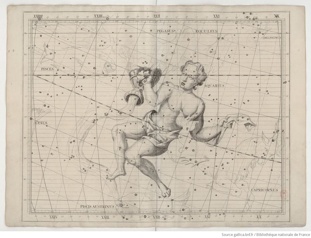
My investigation, using Carte du Ciel software [4] and historical charts, reveals inconsistencies in the Aquarius–Pisces boundary: the line from Beta to Iota Aquarii crosses into Capricornus, clashing with Aquarius’ traditional water-bearer shape [2]. Stars that the IAU assigns to neighboring constellations, such as 11 Pegasi and Eta Piscis Austrini, lie within the traditional Aquarius figure as drawn in Flamsteed’s Atlas Coelestis [13], and the asterisms of Aquarius and Capricornus overlap with no clear border. Pisces incorporates post-telescope stars, highlighting the modern origins of these borders, which evolved significantly in the 17th and 18th centuries [14]. Precession further undermines their relevance in the J2000.0 epoch: boundaries drawn as straight lines in 1875 now appear curved. Stellar proper motion will reshape these boundaries over millennia [15, 16].
These standardized lines exclude non-Western systems, such as the Chinese lunar mansion Xu (Beta Aquarii) [3], the Indigenous Australian Emu in the Sky, and Polynesian Matariki [17]. Across Babylonian, Chinese, Indian, Southeast Asian, Mesoamerican, African, and Polynesian cultures, constellations once forecast the rainy season; the IAU grid preserves none of these roles. Today, the traditional uses of celestial maps (seasonal tracking, storytelling, and timekeeping) are obsolete, supplanted by modern meteorology, atomic clocks, and digital media [18, 19]. As humanity’s perspective shifts beyond Earth, the Earth-centric equatorial coordinate system risks irrelevance, with Delporte’s boundaries potentially losing meaning over time [20, 21].
I propose a dual system: preserving cultural asterisms as a historical archive to maintain their seasonal and cultural significance (e.g., Babylonian Anunitum [9], Polynesian Matariki [22]), expressed as a “Seasonality of Rain Map”; while establishing a universe-centric astronomical mapping reference system based on the International Celestial Reference System (ICRS) [5] and Gaia’s 3D stellar data [6, 7], expressed as a “Modern Utility Map” for astronomers, navigators, and educators. This approach updates IAU standards for long-term precision and relevance, while safeguarding humanity’s diverse astronomical heritage.
3. History
The development of constellation boundaries mirrors humanity’s evolving relationship with the night sky, from dynamic, culturally embedded tools for survival to the precise, standardized frameworks of modern science. This section traces that journey from the earliest sky records, through the Babylonian MUL.APIN and Ptolemy’s Almagest, to the IAU’s 1930 standardization under Eugène Delporte. A key focus is the role of constellations in predicting rainy seasons across cultures, a practical utility that shaped their fluid boundaries before the shift to scientific rigidity.
3.1 Prehistoric and early sky observations
The human record of the sky is far older than writing. Working notes for this study refer to constellations recorded in Ice Age cave paintings at Lascaux in France; Rappenglück has asked whether a rock picture in the cave of Lascaux shows the Pleiades in the Magdalenian era (ca. 15,300 BC) [23]. A study of notched bones from Border Cave, South Africa, highlights one bone with 29 regular notches, which researchers propose may be one of the earliest known lunar tracking tools because of its close alignment with the 29.5-day lunar cycle; the notches were carefully carved with lithic cutting edges, and evidence of long-term manipulation and transport suggests their cultural importance among the San [24]. Further archaeoastronomical evidence includes a luni-solar “time-reckoner” from 8th-millennium BC Scotland [25], interpretations of the Ishango bone [26], Michael Rappenglück’s interpretation of painted dots at Lascaux as “what could be the oldest lunar calendar ever created” [27], the astronomy of Nabta Playa [28], the early history of counting [29], and a debated archaeoastronomical reading of Göbekli Tepe [30, 31, 32].
3.2 Mesopotamia: celestial guides for earthly life
Around 1000 BCE, the Babylonians crafted some of the earliest known star catalogs, exemplified by MUL.APIN [9, 33]. Recorded on cuneiform tablets, this compendium documented stars, constellations, and their heliacal risings (their first pre-dawn appearances) and settings. It lists 66 stars and constellations organized into three “paths” (Enlil, Anu, and Ea) by celestial latitude, records heliacal risings for 34 stars tied to a 360-day “ideal” calendar, and divides the ecliptic into 12 parts, laying the groundwork for the zodiac. The surviving tablets, discovered at Nineveh and other sites and now held in places like the British Museum, date from around 687 BCE but likely reflect much older observations.
These were not decorative patterns but essential tools for survival in Mesopotamia. Constellations like Anunitum (part of modern Pisces) and MUL.GU.LA (“The Great One”, Aquarius) were watched for their heliacal risings, which signaled the onset of the rainy season, a critical cue for farmers in a region dependent on seasonal rains and river flooding. MUL.GU.LA was associated with the god Ea (Enki), the deity of wisdom, magic, and water, and was depicted as a water-pouring figure or vessel linked to the winter rains (around December–January, Kislimu in the Babylonian calendar); MUL.APIN places it in the “Path of Ea”. Stars like Sadalmelik (Alpha Aquarii) and Sadalsuud (Beta Aquarii) were observed for heliacal risings signaling winter. Early boundaries were fluid, defined less by fixed coordinates than by the practical needs of agriculture, navigation, and ritual timing.
The modern constellation Pisces has no direct Babylonian twin. Research suggests the region was represented by Anunitum, identified as the northern fish and named after a goddess linked to Inanna-Ishtar who symbolized spring floods and renewal, and by part of the Swallow (mulŠinūnūtu), which included the western fish of Pisces together with parts of Pegasus. The Babylonian zodiac, developed by the late 5th century BCE, had 12 signs, one of which, “the Tails” (mulZibbatu), corresponds to Pisces and may refer to the cord connecting the two fish. MUL.APIN’s section on the path of the Moon (Tablet I, iv 31 – II i 8) includes both mulŠinūnūtu and mulZibbatu. Eta Piscium (Alpherg) was traditionally known as Kullat Nunu, and late Babylonian sources mention DU.NU.NU, “The Fish-Cord”. A constellation called MUL.KU6 (“The Fish”), associated with Ea, is sometimes treated as a precursor of Pisces, but it corresponds to Piscis Austrinus rather than Pisces proper. For further reading, I recommend Gavin White’s Babylonian Star-lore [34].
| Babylonian entity or star | Description | Modern correspondence |
|---|---|---|
| Anunitum | Northern fish of Pisces; goddess associated with spring floods | Northern fish, incl. Gamma Piscium (mag. 3.70) |
| The Swallow (mulŠinūnūtu) | Includes western fish of Pisces | Western fish, overlaps Pegasus; possibly Beta Piscium (mag. 4.48) |
| “the Tails” (mulZibbatu) | Zodiac sign corresponding to Pisces | Entire constellation Pisces |
| Kullat Nunu | Traditional name, “fish cord” | Eta Piscium (Alpherg, mag. 3.62) |
Other cuneiform records show the empirical and mathematical sophistication of Babylonian astronomy, though none frames anything like a zodiacal “age”. The Venus Tablet of Ammisaduqa (circa 1650 BCE, copied later; Enuma Anu Enlil Tablet 63) tracks Venus’s first and last visibility over 21 years. The Astronomical Diaries (circa 652 BCE–75 CE), over 1,000 tablets, record nightly positions of the Moon, planets, and 31 “Normal Stars” near the ecliptic in cubits (about 2°). Five Jupiter tablets (circa 350–50 BCE), analyzed by Ossendrijver [35], compute Jupiter’s displacement as the area of a trapezoid under a velocity–time curve, and the Lunar Ephemerides (circa 300 BCE–100 CE) predict lunar positions and eclipses with arithmetical Systems A and B.
3.3 Egypt, Greece, and Ptolemy’s Almagest
Egypt had a different celestial system focused on decans rather than a zodiac. The Dendera Zodiac (circa 50 BCE) shows two fish and, some scholars suggest, a water-bearer figure, reflecting Greek influence by the Ptolemaic period rather than an early Egyptian tradition [8, 36]. The Greeks adopted Aquarius from Babylonian MUL.GU.LA; by the time of Eudoxus (circa 400–350 BCE) and Aratus (circa 310–240 BCE) Aquarius is described as the water-bearer, linked to Ganymede, and Pisces as two fish tied together, linked to Aphrodite and Eros escaping Typhon. Hipparchus, around 129 BCE, building on earlier work going back to the Babylonians, used mathematics, understood precession, and produced accurate, text-based results.
By the 2nd century CE, Claudius Ptolemy’s Almagest synthesized these traditions into a structured framework [10, 37]. It catalogs 48 constellations (the 12 of the zodiac, 21 north of the zodiac, and 15 to the south) and positions stars by ecliptic longitude and latitude, aligning them with the Sun’s annual path. Ptolemy did not claim to have observed all these stars himself; he credits earlier astronomers, particularly Hipparchus, and adjusted their positions for precession. His constellations were asterisms (shapes made by connecting stars) and carried cultural weight: Orion as a hunter, Ursa Major as a bear. Historical sources like the Almagest depict constellations as fluid star collections without rigid borders. Ptolemy lists Beta Piscium as a star in the southern part of Pisces. The modern versions of the 48 Greek constellations are not identical to those Ptolemy cataloged. In the 10th century, al-Sufi’s Book of the Fixed Stars (964 CE) carried this tradition into Islamic astronomy [38].
| Constellation | Period | Evidence |
|---|---|---|
| Aquarius | ~3000–2500 BCE | Proto-cuneiform references from Uruk (Louvre AO 6451) to a water-related figure, inferred as MUL.GU.LA |
| Aquarius | ~2000–1800 BCE | Mentions in Babylonian texts (Three Stars Each, MUL.APIN), tied to Ea and winter rains |
| Aquarius | ~700–200 BCE | Greek adoption (Eudoxus, Aratus) as the water-bearer (Ganymede) |
| Pisces | ~1000 BCE | No two-fish constellation; stars of the region belong to Anunitum or the Swallow in MUL.APIN |
| Pisces | ~400–200 BCE | First Greek mention as two fish (Eudoxus, Aratus) |
| Both | ~150 CE | Ptolemy’s Almagest formalizes both constellations and lists their stars |
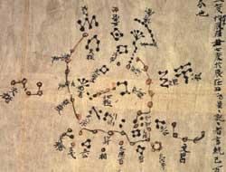
3.4 Cultural rainy-season traditions
Across the ancient world, diverse cultures harnessed constellations to forecast rainy seasons, embedding predictive utility into their celestial maps. Table 3 summarizes the examples assembled in this study [3, 9, 11, 22].
| Culture | Constellations | Usage |
|---|---|---|
| Babylonian | Anunitum (part of modern Pisces); MUL.GU.LA (Aquarius) | Heliacal risings, recorded in MUL.APIN, predicted the Mesopotamian rainy season and timed agricultural activities in a land reliant on seasonal rains and river flooding. |
| Chinese | Azure Dragon (Qinglong); 28 Lunar Mansions (Xiu), e.g., Jiao (Spica) | The heliacal rising of the Azure Dragon in spring heralded the rainy season and the start of planting; mansions like Jiao were linked to rain onset. |
| Indian/Hindu | Nakshatras (27 or 28 lunar stations), e.g., Rohini (Aldebaran) | The Moon’s alignment with Rohini indicated the monsoon’s approach, allowing farmers to prepare for the heavy rains. |
| Southeast Asian | Orion; Pleiades | In regions like Java and Thailand, the rising of Orion’s belt or the Pleiades marked the wet season’s start, critical for rice planting. |
| Mesoamerican | Pleiades; Orion | For the Maya and Aztec, the zenith passage of the Pleiades predicted the rainy season; Orion’s position helped time agricultural cycles. |
| African | Pleiades; Sirius | Among the Dogon of Mali and the Zulu of southern Africa, the appearance of the Pleiades or Sirius forecast the rains and cued planting. |
| Polynesian | Matariki (Pleiades) | The heliacal rising of Matariki signaled both the rainy season and the New Year, guiding fishing and farming. |
These practices reveal a global pattern: constellations were not static but living tools, their boundaries shaped by the imperatives of rain, agriculture, and societal cohesion. The Pleiades recur across continents, from Southeast Asia to Mesoamerica to Polynesia, underscoring their universal utility as a seasonal marker. Other traditions documented in this study’s survey of celestial mapping systems include Indigenous Australian dark constellations such as the Emu in the Sky, Polynesian and Hawaiian star paths used for oceanic wayfinding, and Navajo and Lakota astronomy [17]. None of these systems is represented in the IAU’s 88 boundaries.
3.5 From star atlases to boundaries (1603–1877)
In 1603 Johann Bayer and the artist Alexander Mair published Uranometria, an atlas of 51 copper plates built on 1,005 stars observed by Tycho Brahe plus about 1,000 stars Bayer charted himself. John Flamsteed’s Atlas Coelestis, published posthumously in 1729 to accompany his catalog of 2,935 stars, Historia Coelestis Britannica, became the model for a family of later atlases: Fortin’s “French Flamsteed” (1776, 1795), Bode’s Vorstellung der Gestirne (1782, 1805), Alexander Jamieson’s Celestial Atlas (1822), and Urania’s Mirror (1825) [13, 40]. Bode introduced constellation boundaries snaking between the stars; he was not the first to do this (Didier Robert de Vaugondy in 1764 and Noel André in 1778 preceded him [41]), but he was the most influential. Because Flamsteed had assigned some stars to the wrong constellations, the results were sometimes absurd, with boundaries overlapping neighboring figures. Bode’s Uranographia (1801), rooted in the catalogs of Hevelius and Flamsteed, is generally regarded as the greatest pictorial star atlas [40, 42].
Star charts of the early 20th century still showed perimeter lines that varied from map to map, and some stars were shared between constellations, a tradition extending back to the Almagest, as with Alpha Andromedae, which was also the navel of Pegasus [14]. By the 19th century over a hundred constellations appeared on various charts [43]. The decisive precedent for straight boundaries came from Benjamin Apthorp Gould, whose Uranometria Argentina (1877–1879) cataloged the southern naked-eye stars and replaced meandering freehand lines with boundaries along lines of right ascension and declination for the epoch 1875 [12, 44]. Pisces, meanwhile, came to include post-telescope stars absent from ancient groupings, and its borders evolved significantly in the 17th and 18th centuries [14].
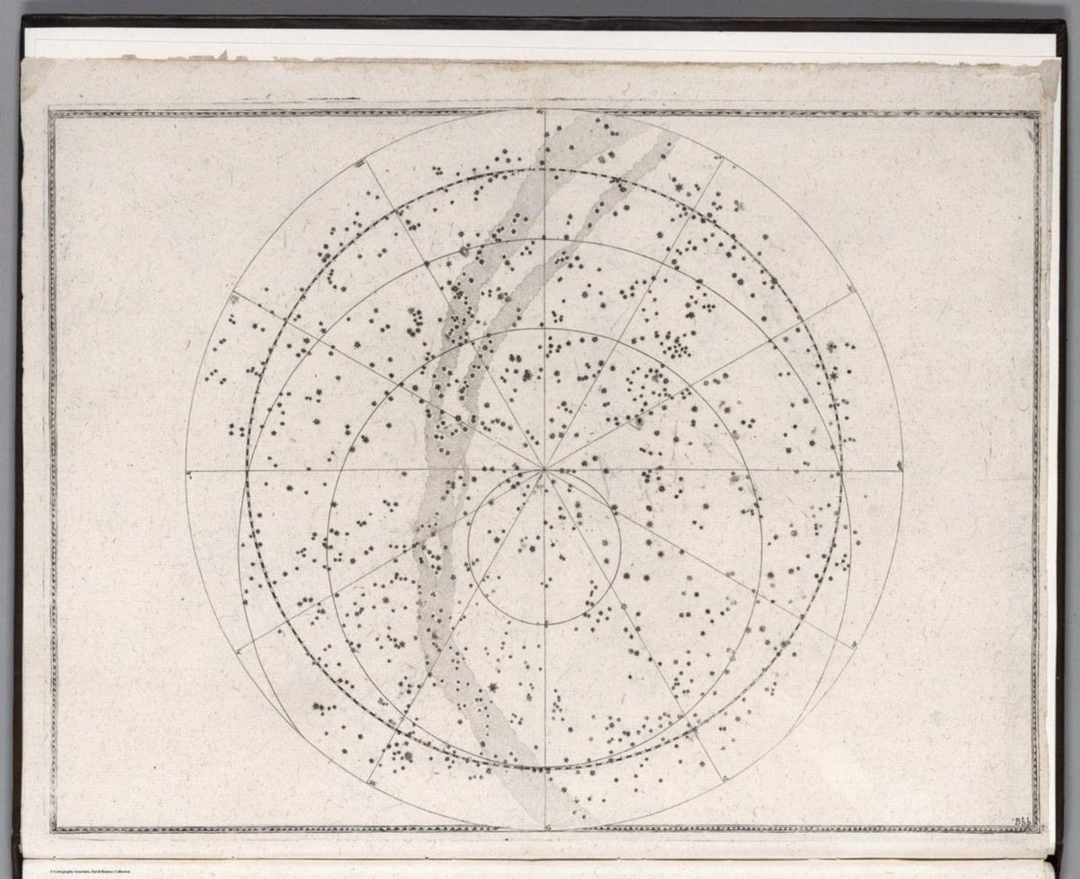
3.6 The IAU’s 1930 standardization
At its first General Assembly in 1922, the IAU agreed on a definitive list of 88 constellations to standardize nomenclature and cover the whole sky; the list incorporated the ancient Greek and Roman constellations and later southern additions by astronomers such as Nicolas Louis de Lacaille, and drew on the Revised Harvard Photometry catalog (1908) of 9,110 naked-eye stars [43, 45]. Delporte did not choose the 88 constellations; his task was to define their boundaries. Eugène Joseph Delporte (1882–1955), of the Royal Observatory of Belgium, was tasked by the IAU in 1925 to draw clear boundaries. A sub-commission (including Bigourdan, Casteels, and Knobel) worked under IAU oversight at the 1925 (Cambridge) and 1928 (Leiden) General Assemblies, but Delporte personally carried out “la délimitation théorique complète” [1]. For the southern sky he adjusted Gould’s boundaries, removing diagonal lines to ensure consistency across the entire sky, and the complete work was published in 1930 as Délimitation Scientifique des Constellations [1, 14].
This was a practical necessity: as astronomy grew into a global, collaborative science, a uniform system was essential for cataloging stars, tracking celestial events, and sharing observations. Delporte ended the practice of shared stars and ensured that every point in the sky belonged to exactly one constellation. Yet this precision came at a cost. No longer tied to heliacal risings or rainy seasons, the boundaries became mathematical containers optimized for star classification rather than human experience. Delporte fundamentally changed the constellation system by drawing straight lines through everything, placing traditional stars in non-traditional asterisms, and lumping newly discovered stars into these boxes.
3.7 Cultural roots versus scientific rigor
Early constellations, from Babylonian Anunitum to Polynesian Matariki, were dynamic, their meanings rooted in human needs: predicting rains, guiding voyages, or marking time. The IAU system, by contrast, prioritizes mathematical clarity, excelling in scientific utility but losing cultural depth. Meanwhile, the 20th century transformed humanity’s perspective: in 1917 Harlow Shapley published a map of the distribution of globular clusters and concluded that the solar system lies far from the center of our galaxy, and in 1924 Edwin Hubble resolved individual stars in other galaxies. Constellation boundaries evolved from fluid, culturally vital tools, through Ptolemy’s systematic synthesis, to the IAU’s rigid scientific standard, a progression that enabled astronomical precision but distanced the stars from their original roles.
4. Technical details
This section details the technical basis of the study: the epochs and reference frames involved, Delporte’s method and datasets, the effect of precession and related motions, my analysis of the Aquarius–Pisces boundary, the three-dimensional perspective offered by Gaia, and the concept and methodology of the two proposed maps, followed by next steps.
4.1 Epochs, time systems, and reference frames
A Besselian epoch is based on the Besselian year, the mean tropical year at B1900.0 (precisely 365.242198781 days). B1900.0 corresponds to January 0.81352, 1900, or JD 2415020.31352, and a Besselian epoch is calculated as B = 1900.0 + (JD − 2415020.31352) / 365.242198781. Besselian epochs were used with catalogs such as the FK4 and remain relevant for legacy data, including the 1930 boundaries.
A Julian epoch uses the Julian year of 365.25 days. The standard epoch J2000.0 corresponds to January 1, 2000, at 12:00 Terrestrial Time (TT), or Julian Date 2451545.0, and a Julian epoch is J = 2000.0 + (JD − 2451545.0) / 365.25. The Julian Day count itself begins on January 1, 4713 BCE, a date chosen by the 16th-century scholar Joseph Justus Scaliger because several calendar cycles converge there (the 15-year Roman indiction, the 28-year solar cycle, and the 19-year Metonic cycle) and because it keeps all historical dates positive. Julian epochs have largely replaced Besselian epochs because of their fixed year length and their alignment with current IAU standards.
The IAU System of Astronomical Constants of 1976 adopted J2000.0 as the new fundamental epoch, replacing B1950.0. The Fifth Fundamental Catalogue (FK5; Fricke et al., 1988), based on visual observations of star positions, carried systematic errors and a precision of 30–40 milliarcseconds [46]. Very Long Baseline Interferometry (VLBI) of extragalactic radio sources offered milliarcsecond precision and a frame with no measurable proper motion. Following IAU Colloquium 127 (“Reference Systems”, Virginia Beach, October 1990), IAU Resolution A4 (1991, Buenos Aires) defined relativistic space-time coordinate systems, later formalized as the Barycentric and Geocentric Celestial Reference Systems (BCRS and GCRS), whose grids show no global rotation relative to distant extragalactic objects, with the principal plane as close as possible to the mean equator of J2000.0. This laid the groundwork for the International Celestial Reference System (ICRS), adopted in 1997 and realized through the International Celestial Reference Frame (ICRF) in 1998 [5]. The IAU boundaries, originally defined in a Besselian frame, are now expressed in J2000.0 coordinates.
| System | Origin | Fundamental plane | Coordinates | Primary use |
|---|---|---|---|---|
| ICRS | Solar system barycenter | Defined by quasar positions | RA, Dec | High-precision astrometry |
| BCRS | Solar system barycenter | Aligned with ICRS at J2000.0 | RA, Dec | Solar system dynamics, distant objects |
| GCRS | Earth’s center of mass | Aligned with ICRS at J2000.0 | RA, Dec | Near-Earth objects, satellites |
| Equatorial | Earth’s center | Earth’s equatorial plane | RA, Dec | Earth-based observations |
| Ecliptic | Earth’s center or barycenter | Ecliptic plane | Longitude, latitude | Solar system studies |
| Galactic | Galactic center | Galactic plane | Longitude, latitude | Milky Way structure mapping |
| Horizontal | Observer’s location | Horizon | Altitude, azimuth | Real-time observations |
| Supergalactic | Local supercluster center | Supergalactic plane | Longitude, latitude | Large-scale structure studies |
4.2 Delporte’s method, epoch, and datasets
Delporte created fixed, non-overlapping boundaries in the equatorial coordinate system, drawing them along meridians of right ascension and parallels of declination. In Délimitation Scientifique des Constellations (p. 6), Delporte describes using “méridiens d’ascension droite et des parallèles de déclinaison pour l’équinoxe de 1875,0”, which produced a rectilinear grid at that epoch and aligned the work with Gould’s southern boundaries in the Uranometria Argentina [1, 47, 48]. The boundary coordinates for each edge are published in the Délimitation [1].
His methodology relied on two kinds of dataset [1, 14, 43]:
- Variable star lists. The IAU specified, at the request of its Variable Stars committee, that all variable stars with established designations should remain in the constellation to which they had already been assigned. Delporte consulted catalogs such as Prager’s Katalog und Ephemeriden Veränderlicher Sterne (1928) [49], writing that the work “devait tenir compte de la désignation déjà acquise des étoiles variables et conserver ces étoiles dans leurs astérismes respectifs” (p. 7).
- Star catalogs. For the southern sky he built on Gould’s Uranometria Argentina; for the north he followed earlier atlases such as Argelander’s Uranometria Nova (1843) and Bode’s Uranographia (1801), keeping his lines close to the “tracés non définis figurant sur les atlas modernes” (p. 7) so as to minimize star reassignments [42].
Delporte’s further criteria, from pages 6–8 of the Délimitation, were to maintain “un accord suffisant avec les descriptions du ciel de Ptolémée” (p. 6); to avoid “changements d’étoiles de constellations à constellations” (p. 7), keeping major stars in their historical constellations; and to serve practical astronomy: “l’observation systématique des étoiles filantes et des bolides, l’étude et la dénomination des variables, l’observation des novae, etc.” (p. 6). Delporte did not invent Pisces or Aquarius; he formalized their spatial limits while respecting their traditional stars [1].
The resulting system delivered real benefits. Precision: right ascension and declination lines allow any object to be located and its constellation determined immediately. Standardization: 88 fixed regions resolved the ambiguity of earlier, overlapping boundaries and gave astronomers worldwide a shared map. Historical continuity: preserving variable star assignments and aligning with established catalogs minimized disruption to decades of records. Its limitations are equally clear: precession-induced curvature (Section 4.3) and reduced cultural relevance, since the boundaries prioritize star containment over the seasonal and narrative roles constellations once played.
| Aspect | Details |
|---|---|
| Variable star lists | Variable stars and their assigned constellations, ensuring naming consistency |
| Star catalogs | Positions of all stars, particularly Gould’s Uranometria Argentina for the southern hemisphere |
| Measurement method | Right ascension and declination for the equinox of 1875.0, giving rectilinear boundaries at that epoch |
| Reasons for the choice | Consistency with the coordinate system, preservation of variable star assignments, alignment with Gould’s work, minimizing disruption |
4.3 Precession, nutation, proper motion, and the J2000.0 frame
By 1925–1930 astronomers were well aware of precession (the Earth’s roughly 26,000-year axial wobble), nutation (small oscillations of the axis with an ~18.6-year cycle), and proper motion (stars’ individual movements), all of which make any fixed epoch transient. Precession moves the vernal equinox westward along the ecliptic at about 50.29 arcseconds per year, or about 1 degree every 72 years [47]. Boundaries set in 1930 as straight lines for the B1875.0 epoch therefore appear curved in the modern J2000.0 frame, which reduces their intuitive clarity for educators, amateurs, and professionals using J2000.0-aligned charts [20, 48].
If Delporte were defining boundaries today with his original method (straight lines of RA and Dec in the current frame), his new J2000.0 lines would not coincide with the current IAU boundaries, which are his original lines converted to J2000.0 and now curved. The IAU has kept the original boundaries, converted to J2000.0, preserving historical star assignments and choosing continuity over methodological consistency [50]. Fixed to a historical epoch, the boundaries cannot adapt to stellar drift or evolving human perspectives.
The precession–nutation models themselves are still being refined. The IAU2000 resolution (B1.6) introduced a nutation model for a non-rigid Earth with corrections for precession rates in longitude and obliquity, and IAU2006 updated precession, but the two are not fully consistent. Bizouard computed corrections to IAU2000/2006 parameters from five VLBI data series (two individual and three combined) and found systematic differences that often exceed the random errors, recommending that several series be compared [51]. Ferrándiz showed that IAU2006 precession did not achieve full consistency with the IAU2000A nutation, owing to differences in the obliquity constant and longitude rates at J2000.0, and proposed microarcsecond-level corrections expressed as celestial pole offsets dX and dY in three models: (a) a geometrical effect of obliquity change, (b) a J2-rate effect, and (c) an effect of precession-parameter changes [52]. For model (b), preferred for full secular-mixed terms, dXb = +15.4t sinΩ + 1.4t sin(2F−2D+2Ω) − 0.6t² cosΩ and dYb = −25.4t cosΩ − 1.8t cos(2F−2D+2Ω) − 0.3t² sinΩ (μas, t in Julian centuries since J2000.0). Tests over 1984–2003, 1900–2100, and 1984–2018 showed that a degree-5 polynomial absorbed over 90% of the variance over the short interval, masking the inconsistencies, while longer periods revealed quasi-periodic cycles. Related work by Capitaine et al. [53] and the Second Earth Orientation Parameters Prediction Comparison Campaign [54] supports this ongoing refinement.
Over longer periods, stellar proper motion will reshape the boundaries’ stellar content [15, 16]. Sadalmelik, for example, moves at about 20 milliarcseconds per year; over 10,000 years such motions scatter the familiar patterns further.
4.4 The Aquarius–Pisces boundary analysis
Methods
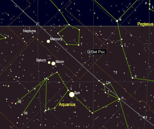
I used Carte du Ciel software [4] to map the IAU’s 1930 boundaries for Aquarius and Pisces, visualizing their right ascension and declination lines in the J2000.0 epoch, and used Stellarium to cross-validate the boundaries and ensure accurate rendering of the modern sky. Digitized historical star charts, including Ptolemy’s Almagest and MUL.APIN, were accessed through online archives (e.g., the British Museum’s digital collections) to compare pre-1930 depictions [33, 37]. Artistic representations from Greco-Roman, Islamic, and Chinese traditions were drawn from digitized manuscripts, such as Islamic celestial globes, to assess historical constellation shapes [38, 39], and the Aquarius plate of Flamsteed’s Atlas Coelestis served as a reference for the traditional figure [13]. The analysis identified boundary discrepancies using coordinate overlays and visual comparisons. This hybrid approach, blending modern software with historical sources, allowed a critique of the IAU framework’s alignment with both astronomical precision and cultural heritage.
Findings
- The straight line from Beta to Iota Aquarii crosses into Capricornus, disrupting Aquarius’ traditional water-bearer shape [2].
- On Flamsteed’s Aquarius plate, 11 Pegasi is a major star of the Aquarius asterism, and HD 209522, HD 210848, and Eta Piscis Austrini lie clearly within the Aquarius figure, although the IAU boundaries assign them elsewhere or leave them at the margins [13].
- The asterisms overlap: Capricornus sits in the arm of Aquarius, and there is no clear border between them. The asterisms were never meant to have borders.
- Pisces includes post-telescope stars, absent from ancient groupings [14]. When Flamsteed charted the known stars, he included stars visible with early telescopes but largely kept them within the known asterisms; Delporte’s straight lines placed traditional stars in non-traditional asterisms and lumped newly discovered stars into the boxes.
Historical sources, like Ptolemy’s Almagest, depict constellations as fluid star collections without rigid borders, a practice lost in Delporte’s framework. These findings highlight the arbitrariness of the IAU boundaries and question their alignment with both historical traditions and modern astronomical needs. Future work could explore integrating non-Western systems such as the Chinese lunar mansions [3].
4.5 The three-dimensional perspective
Constellations like Aquarius appear as two-dimensional patterns on the celestial sphere, but their stars are three-dimensional bodies at very different distances, determined via parallax [7]. The IAU’s boundaries are drawn in the 2D equatorial system, implicitly assuming a spherical shell around Earth; in reality no physical boundary connects these stars. Sadalmelik lies ~520 light-years away and Sadalsuud ~540 light-years, while the distance of HD 224677, cataloged later in telescopic surveys, is uncertain (possibly 100–1,000 light-years). These distances show no clustering. Viewed from deep space (say, 10,000 light-years away), parallax would dismantle the pattern, and proper motion over 10,000 years would scatter it further. Some faint Aquarius stars may belong to the Helmi Stream, a tidal remnant of a dwarf galaxy merged with the Milky Way, identified with Gaia data: a 3D structure detectable in motion and chemistry but unrelated to the water-bearer’s outline [55]. Over a billion years, stellar evolution and galactic dynamics will erase Aquarius entirely [15].
For mapping beyond Earth, 3D reference systems such as galactic or barycentric coordinates replace flat boundaries. A galactic-equator layer is one simple bridge between the two views: in J2000.0 the galactic north pole lies at RA 12h 51.4m, Dec +27° 07′; the galactic equator passes through the galactic center in Sagittarius (RA ~17h 45m, Dec −29°), crosses the celestial equator at approximately RA 6h 45m and 18h 45m, and crosses the ecliptic at approximately 96° and 276° ecliptic longitude. It can be drawn in Carte du Ciel or Stellarium, or computed with libraries such as Astropy.
4.6 The proposed dual system
I propose a dual system: a cultural asterism archive that preserves the seasonal and cultural significance of historical star patterns, and a universe-centric astronomical mapping reference system built on the ICRS and Gaia’s 3D stellar data [5, 6, 7]. The two components are developed as two contrasting maps (a Seasonality of Rain Map and a Modern Utility Map) intended to bridge the amorphous maps of antiquity with the rigid delineations of modernity. Both respond to an assessment of who uses the boundaries today (Table 6).
| User | Needs | Fit of the current system |
|---|---|---|
| Astronomers | Cataloging stars, galaxies, and other objects with exact coordinates | Precision is a strength, but precession complicates long-term studies |
| Educators and amateurs | Intuitive groupings that match naked-eye views | Boundaries are overly intricate |
| Navigators | Stars for traditional or emergency navigation (though GPS dominates) | Benefit from key stars, not full constellations: a mismatch with the system’s scope |
| Cultural historians | Constellations’ historical and cultural meanings | The framework detaches constellations from their cultural significance |
Seasonality of Rain Map (cultural asterism archive)
Concept. The Seasonality of Rain Map restores the historical and cultural significance of constellations by redrawing boundaries to reflect ancient associations with rainy seasons. From Anunitum signaling Mesopotamian rains to the Pleiades marking wet seasons in Southeast Asia and Mesoamerica and Matariki marking the Polynesian New Year, stars once guided survival [9, 22]. The map reconnects them to Earth’s cycles, enriching education and historical study and safeguarding Indigenous and ancient knowledge.
Methodology. The map draws on ancient records such as MUL.APIN, which catalogs heliacal risings and their connections to seasonal events, and on cultural sources such as the Chinese Xiu and Indian Nakshatras [3, 11, 33]. Stars and patterns historically associated with rainy periods become anchors for new boundaries tied to heliacal risings or zenith passages (for example, Pisces shaped by Anunitum and Taurus by the Pleiades). Two challenges must be managed: ancient records are often incomplete or ambiguous and require careful interpretation and cross-referencing, and precession has altered stellar positions over millennia, so historical positions must be adjusted to J2000.0.
Modern Utility Map (universe-centric reference system)
Concept. The Modern Utility Map serves today’s users through coordinate systems and reference frames rather than constellation boundaries: precision for astronomers, visibility for navigators, and intuitive groupings for educators and amateurs. Unlike the current system, which prioritizes historical continuity over functionality, it creates a flexible, user-focused framework that adapts to contemporary demands and to new discoveries.
Methodology. The foundation is the 3D stellar data from the Gaia mission, which provides highly accurate positions, distances, and motions for over a billion stars [6, 7]. Using right ascension, declination, and parallax, star positions can be converted to Cartesian coordinates (x, y, z) centered on the solar system barycenter and aligned with the ICRS/ICRF, whose tie to distant quasars provides long-term stability [5]. The map can then reflect the true spatial distribution of stars rather than 2D projections, without drawing constellation boundaries. Equally important are user-defined criteria gathered through surveys and workshops: astronomers seek coordinate accuracy, navigators need bright stars (magnitude < 6), and educators favor clear patterns (e.g., Orion’s belt and shoulders). Measurable criteria include precision (alignment with Gaia coordinates), visibility (star magnitude thresholds), and educational value (pattern simplicity). The process is iterative: collecting feedback and refining the map accordingly.
Extension beyond Earth: the Planetary Adaptive Constellation System
A companion proposal extends the universe-centric approach into a Planetary Adaptive Constellation System (PACS). PACS combines a universal 3D star map, stored in a coordinate-agnostic barycentric catalog built from Gaia DR3, with dynamic overlays that adapt constellation boundaries to an observer’s planet, location, and time. The overlay algorithms transform barycentric coordinates into a planet’s equatorial system using its axial tilt (e.g., 23.44° for Earth and 25.19° for Mars), use ephemeris data (e.g., from NASA’s Horizons system) for orbital position (Mars has a 687-day orbital period), model atmospheric transmission by wavelength (e.g., near-infrared for Titan’s methane haze, infrared windows for Venus, dust storms on Mars), and then group stars into boundaries using techniques such as clustering or Voronoi tessellations. The proposal illustrates this with Mars, where familiar patterns such as Orion might appear distorted and new local formations (a hypothetical “Red Plains Cluster”) could emerge.
The PACS proposal also specifies location input (manual coordinates, e.g., Gale Crater at 4.5° S, 137.4° E, or automatic detection where positioning systems exist), custom body-centric grids for irregular bodies, a “Live Mode” for spacecraft, interfaces to SIMBAD, NASA’s Horizons, and navigation formats, and a phased software plan building on Stellarium with later VR/AR modules. Its validation targets are positional accuracy within 1 arcsecond against Gaia DR3 and mission data, an 80% approval rating in beta tests (System Usability Scale), at least 60 FPS in AR and 90 FPS in VR, and update latency within 100 milliseconds.
4.7 Next steps
Implementing these maps requires a structured approach to test their feasibility and build support. I propose:
- Pilot studies. Trial the Seasonality of Rain Map on constellations with well-documented ties to rainy seasons, such as Pisces (Anunitum), MUL.GU.LA, or Taurus (Pleiades), using MUL.APIN and cultural data; trial the Modern Utility Map on a specific region such as Orion, using Gaia data and user feedback.
- Wider analysis. Extend the boundary analysis to other constellations, such as Orion, to determine whether similar discrepancies exist.
- Stakeholder collaboration. Engage historians and archaeologists to interpret ancient texts, astronomers to validate coordinates, educators to shape teachable patterns, and navigators. Collaborate with cultural astronomers (such as J. Holbrook, D. W. Hamacher, and others whose contributions on cultural astronomy appear in IAU General Assembly proceedings [17]) to integrate non-Western systems, such as the Chinese lunar mansion Jiao, into a supplementary framework.
- Criteria development. For the Seasonality of Rain Map, define what qualifies as a “historical association” (e.g., explicit mentions in MUL.APIN), recording each culture’s own sky rather than choosing between conflicting sources. For the Modern Utility Map, set measurable standards for precision, visibility, and simplicity within its coordinate systems and reference frames.
- IAU and public engagement. Engage the IAU community through workshops to develop criteria that separate scientific mapping from constellation boundaries, balancing scientific utility with global heritage and exploring the maps as supplementary systems rather than replacements for the current standard; use public outreach and citizen science to gather support and feedback.
Challenges remain: integrating fragmented historical records with modern data adjusted for precession, gaining IAU acceptance, securing buy-in from users accustomed to familiar boundaries, and resourcing the creation and distribution of evolving digital maps. They are significant but surmountable with rigorous testing and collaboration.
5. Conclusion
Scientific sky mapping and the constellations should be divorced: astronomers need coordinate systems and reference frames such as the ICRS, while constellation boundaries belong to the people of each time and culture. Constellations have long guided humanity, transitioning from culturally significant tools (such as the Babylonian star charts linking Anunitum to seasonal rains) to the standardized, precise boundaries set by the IAU in 1930. This shift brought uniformity to astronomy and enabled global collaboration, but it introduced persistent limitations. Precession has warped the once-straight boundaries, misaligning them with modern J2000.0 coordinates, while the focus on mathematical precision has distanced constellations from their cultural and practical roots. My analysis of the Aquarius–Pisces region shows how arbitrary the lines can be: they cut through the water-bearer’s figure, cross into Capricornus, and absorb post-telescope stars.
To address this, I propose a dual system: a Seasonality of Rain Map that preserves cultural asterisms as a historical archive of their seasonal roles, and a Modern Utility Map that establishes a universe-centric reference system based on the ICRS and Gaia’s 3D data, offering precision for astronomers, visibility for navigators, and simplicity for educators. As humanity’s perspective shifts beyond Earth, such a framework can also extend to other worlds. Realizing it requires pilot studies, collaboration among astronomers, historians, and educators, and clear criteria, developed with the IAU, that keep scientific mapping in coordinate systems and reference frames and leave constellation boundaries to each culture and time. How can we redefine the sky for a global audience? By pursuing this roadmap, we can update IAU standards for long-term precision and relevance while safeguarding humanity’s diverse astronomical heritage.
6. Reference links
References are numbered in order of first citation. URLs are reproduced exactly as originally recorded. Links were checked on October 10, 2026; links that did not load are flagged.
- [1] Delporte, E. (1930). Délimitation Scientifique des Constellations. Royal Observatory of Belgium.
- [2] International Astronomical Union. (1930). IAU Constellation Boundaries Map. Adopted at the 3rd General Assembly, Leiden, Netherlands.
- [3] Xiaochun, S., & Kistemaker, J. (1997). The Chinese Sky During the Han: Constellating Stars and Society. Sinica Leidensia, Vol. 38, Brill.
- [4] Chevalley, P. (n.d.). Carte du Ciel - SkyChart [Computer software]. Retrieved from https://www.ap-i.net/skychart/en/start
- [5] USNO. (n.d.). International Celestial Reference System (ICRS).
- [6] ESA. (2018). Gaia Creates Richest Star Map of Our Galaxy and Beyond. Retrieved from https://www.esa.int/Science_Exploration/Space_Science/Gaia/Gaia_creates_richest_star_map_of_our_Galaxy_and_beyond
- [7] Gaia Collaboration, et al. (2018). Gaia Data Release 2: Summary of the contents and survey properties. Astronomy & Astrophysics, 616, A1.
- [8] Egypt Museum. (n.d.). The Dendera Zodiac [Bas-relief]. Displayed at the Louvre Museum, Paris, France (E 13420). Retrieved from https://egypt-museum.com/the-dendera-zodiac/
- [9] Hunger, H., & Steele, J. (2019). The Babylonian Astronomical Compendium MUL.APIN. Routledge.
- [10] Ridpath, I. (n.d.). Ptolemy’s Almagest. Retrieved from http://www.ianridpath.com/startales/almagest.html
- [11] Harness, D. (2020). The Nakshatras of Vedic Astrology: Ancient & Contemporary Usage. Retrieved from https://dennisharness.com/articles/the-nakshatras-of-vedic-astrology-ancient-contemporary-usage/
- [12] Paolantonio, S., & García, B. (2019). Uranometría Argentina and the constellation boundaries. Proceedings of the International Astronomical Union, 13(S349), 505-509.
- [13] Flamsteed, J. (1646-1719). Atlas coelestis / by the late Reverend John Flamsteed. Bibliothèque nationale de France, Gallica. https://gallica.bnf.fr/ark:/12148/btv1b53096741t/f54.item
- [14] Ridpath, I. (n.d.). Constellation boundaries. Retrieved from http://www.ianridpath.com/boundaries.html
- [15] Binney, J., & Tremaine, S. (2008). Galactic Dynamics. Princeton University Press.
- [16] KQED. (2012). Do Constellations Change Over Time? Retrieved from https://www.kqed.org/quest/41313/do-constellations-change-over-time
- [17] Holbrook, J., Hamacher, D. W., et al. (2015-2018). Contributions on cultural astronomy. IAU General Assembly Proceedings, Honolulu (2015) and Vienna (2018). Retrieved from http://cdsarc.u-strasbg.fr/viz-bin/Cat?VI/49
- [18] Aveni, A. (2001). Empires of Time: Calendars, Clocks, and Cultures. University Press of Colorado.
- [19] Stern, D. P. (2004). The History of Timekeeping. Retrieved from http://www-istp.gsfc.nasa.gov/stargaze/Stimkeep.htm (link not reachable on Oct 10, 2026)
- [20] Cloudy Nights. (2017). Constellation Boundaries and Precession. Retrieved from https://www.cloudynights.com/topic/580180-constellation-boundaries-and-precession/
- [21] Kaler, J. B. (2012). The Ever-Changing Sky: A Guide to the Celestial Sphere. Cambridge University Press.
- [22] Te Ara - The Encyclopedia of New Zealand. (n.d.). Matariki – Māori New Year. Retrieved from https://teara.govt.nz/en/matariki-maori-new-year
- [23] Rappenglück, M. (1996). The Pleiades in the “Salle des Taureaux”, Grotte de Lascaux. Does a Rock Picture in the Cave of Lascaux Show the Open Star Cluster of the Pleiades at the Magdalenian Era (ca. 15,300 BC)? In Astronomy and Culture, pp. 217-225. https://www.academia.edu/217225/The_Pleiades_in_the_Salle_des_Taureaux_Grotte_de_Lascaux
- [24] d’Errico, F., Backwell, L., Villa, P., Degano, I., Lucejko, J. J., Bamford, M. K., Higham, T. F. G., Colombini, M. P., & Beaumont, P. B. (2012). Early evidence of San material culture represented by organic artifacts from Border Cave, South Africa. Proceedings of the National Academy of Sciences, 109(33), 13214-13219. https://www.pnas.org/doi/10.1073/pnas.1204213109
- [25] Gaffney, V., Fitch, S., Ramsey, E., Yorston, R., Ch'ng, E., Baldwin, E., Bates, R., Gaffney, C., Ruggles, C., Sparrow, T., McMillan, A., Cowley, D., Fraser, S., Murray, C., Murray, H., Hopla, E. and Howard, A. 2013 Time and a Place: A luni-solar 'time-reckoner' from 8th millennium BC Scotland, Internet Archaeology 34. https://intarch.ac.uk/journal/issue34/1/index.html Also given as https://doi.org/10.11141/ia.34.1
- [26] Pletser, V. (2012). Does the Ishango Bone Indicate Knowledge of the Base 12? An Interpretation of a Prehistoric Discovery, the First Mathematical Tool of Humankind. arXiv preprint arXiv:1204.1019. https://arxiv.org/abs/1204.1019
- [27] Whitehouse, D. (2000, October 16). Oldest lunar calendar identified. BBC News Online. http://news.bbc.co.uk/2/hi/science/nature/975360.stm
- [28] Malville, J. M., et al. (1998). Astronomy of Nabta Playa. African Skies, 2, 1-4. https://www.africanastronomy.org/african-skies-2-1998/ (link not reachable on Oct 10, 2026)
- [29] Rudman, P. S. (2007). How Mathematics Happened: The First 50,000 Years. Prometheus Books. https://www.prometheusbooks.com/books/9781591024774-how-mathematics-happened (link not reachable on Oct 10, 2026)
- [30] Sweatman, M. B., & Tsikritsis, D. (2017). Decoding Göbekli Tepe with archaeoastronomy: What does the fox say? Mediterranean Archaeology and Archaeometry, 17(1), 233-250. https://maajournal.com/Issues/2017/Vol17-1/Full17-1.pdf (link not reachable on Oct 10, 2026)
- [31] Notroff, J., Dietrich, O., & Schmidt, K. (2017). Response to Sweatman and Tsikritsis. Mediterranean Archaeology and Archaeometry, 17(2), 1-4. https://maajournal.com/Issues/2017/Vol17-2/Full17-2.pdf (link not reachable on Oct 10, 2026)
- [32] Krupp, E. C. (2017). Göbekli Tepe and the Stars. Sky & Telescope, 134(3), 58-61. https://skyandtelescope.org/astronomy-news/gobekli-tepe-and-the-stars/ (link not reachable on Oct 10, 2026)
- [33] Hunger, H., & Pingree, D. (1989). MUL.APIN: An Astronomical Compendium in Cuneiform. Archiv für Orientforschung.
- [34] White, G. Babylonian Star-lore. (Recommended for further reading; no further details given.)
- [35] Ossendrijver, M. (2016). [Babylonian Jupiter tablets]. Science. (Cited without title.)
- [36] Louvre Museum. (n.d.). Dendera Zodiac [Bas-relief]. Louvre Museum, Paris, France. Inventory number E 13420. Retrieved from https://collections.louvre.fr/en/ark:/53355/cl010001614
- [37] Ptolemy, C. (150 CE). Almagest. Translated by G. J. Toomer (1998). Princeton University Press.
- [38] Hafez, I. (2010). Abd al-Rahman al-Sufi and his Book of the Fixed Stars: A Journey of Re-discovery (Doctoral dissertation). James Cook University, Australia.
- [39] Astronomy. (n.d.). Figure 2.9: Dunhuang Star Chart. In Astronomy: 2.2 Ancient Astronomy Around the World. Retrieved from https://pressbooks.online.ucf.edu/astronomybc/chapter/2-2-ancient-astronomy-around-the-world
- [40] Ridpath, I. Antique star atlases. Ian Ridpath’s Star Tales (web page; no URL given in the source).
- [41] Warner, D. J. The Sky Explored. (Cited via Ridpath’s Antique star atlases page; no further details given.)
- [42] Bode, J. E. (1801). Uranographia. Digitized edition, New York Public Library Digital Collections. https://digitalcollections.nypl.org/items/510d47dc-8952-a3d9-e040-e00a18064a99/book?parent=c0ea8450-c6b6-012f-d9a8-58d385a7bc34#page/17/mode/2up
- [43] International Astronomical Union. The Constellations | IAU (web page; no URL given in the source).
- [44] Ridpath, I. Star Tales – Benjamin Gould and the Uranometria Argentina (web page; no URL given in the source).
- [45] Constellation List – Constellation Guide (web page; no URL given in the source).
- [46] Fricke, W., et al. (1988). Fifth Fundamental Catalogue (FK5).
- [47] Eugène Delporte and the Constellation Jigsaw – Cosmic Reflections (web article; no URL given in the source).
- [48] Why are IAU constellation boundaries not rectilinear? – Astronomy Stack Exchange (web page; no URL given in the source).
- [49] Prager, R. (1928). Katalog und Ephemeriden Veränderlicher Sterne. (As named in the source.)
- [50] How were the constellation boundaries set? – Astronomy.com (web article; no URL given in the source).
- [51] Bizouard, C. (2014). On the accuracy of the theory of precession and nutation. Astronomy Reports.
- [52] Ferrándiz, J. M., et al. (2020). A First Assessment of the Corrections for the Consistency of the IAU2000 and IAU2006 Precession-Nutation Models. SpringerLink.
- [53] Capitaine, N., et al. (2005; 2008). Work on IAU precession-nutation formulae; Celestial Mechanics and Dynamical Astronomy (2008). (Cited without full details.)
- [54] Prospects of Predicting the Polar Motion Based on the Results of the Second Earth Orientation Parameters Prediction Comparison Campaign (2023). Earth and Space Science.
- [55] Helmi, A., et al. (2018). Streams in the Gaia era. Nature Astronomy, 2, 805-811.
Additional sources (not cited in the text)
- Science Photo Library. (n.d.). Hémisphère Boréal [Image]. Retrieved from https://www.sciencephoto.com
- Van Buren, E. D. (1945). Symbols of the Gods in Mesopotamian Art. Analecta Orientalia, 23. University of Pennsylvania Museum, Artifact U.11572.
- Link without a full citation: https://spsweb.fltops.jpl.nasa.gov/portaldataops/mpg/MPG_Docs/Source%20Docs/USNO_Circular_5.1.pdf (link not reachable on Oct 10, 2026)
- Link without a full citation: https://baas.aas.org/pub/2023n2i104p23/release/1%22
- Link without a full citation: https://arxiv.org/abs/0905.2315
- Link without a full citation: https://ashishmahabal.net/
- Link without a full citation: https://cxc.cfa.harvard.edu/xrayschool/talks/statistics.pdf
- Link without a full citation: https://arxiv.org/pdf/1903.06796
- Link without a full citation: https://pma.caltech.edu/people/george-djorgovski
- Link without a full citation: https://arxiv.org/abs/1208.2480
- Link without a full citation: https://stat.wisc.edu/staff/cisewski-kehe-jessi/
- Link without a full citation: https://arxiv.org/pdf/1909.11714
- Link without a full citation: https://www.spacescience.org/bio.php?emp=PYFISHER